Tuesday, October 29, 2013

Bishop Creek Lakes Show Historic Shorelines

These are Lake Sabrina and South Lake in the Bishop Creek Basin of the Southern Sierra Nevada Mountains; they are at an historic low.  The light areas around the lake shores are usually under water.  This is a rare sight of the historic shorelines, the way they used to look before they were damned for power by Southern California Edison.  Lake Sabrina’s dam has been in existence since 1908 (Wikipedia).


Sierra Nevada - Lake Sabrina
Lake Sabrina, Sierra Nevada Mountains - Historic Shoreline


Sierra Nevada - southlake
South Lake, Sierra Nevada Mountains - Historic Shoreline

Years of drought have taken their toll on the watersheds that feed these lakes, as it has elsewhere. Generally, melting snow fields create runoff in the early summer, and then later melting ice takes over.  But with many years of drought, the ice has not been replenished...and it’s going away.  If we don’t get substantial precipitation over the next few years to reload the ice packs, we may see the lowest runoff in human memory.

Thursday, October 24, 2013

Hiking Eureka Valley’s Last Chance Range Canyons

Fall temperatures always invite us to explore new areas east of the Sierra Nevada...in this case, an invitation to the desert valleys east of Owens Valley.  Eureka Valley is just an hour’s drive from Bishop and is made up of some of the most beautiful mountains outside of Death Valley.  Recently we enjoyed our third exploration of the Last Chance Range with its series of sinuous canyons that make up the eastern portion of the valley.   Halfway to the Eureka Sand Dunes on Eureka Valley Road (about 5 miles) is a patch of white, which I assume to be the old staging area of material mined near the mouth of our target canyon.
Death Valley  Nationa Park - Last Chance Range

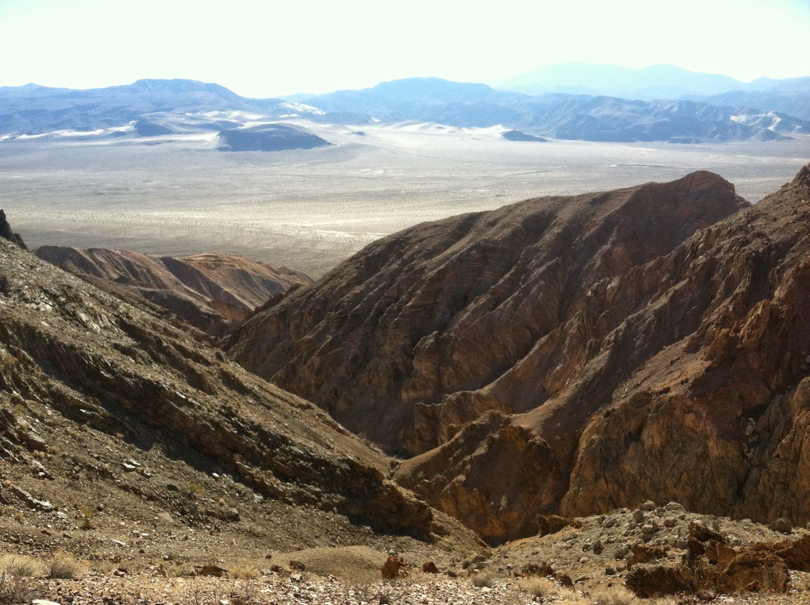
A half mile walk on faded dirt up an alluvial fan took us to the beginning of the gully. The twisted and contorted ocean sediments that make up the gulch produce some interesting rock formations.
Death Valley  Nationa Park - Last Chance Range - geology Death Valley  Nationa Park - Last Chance Range - geology Death Valley  Nationa Park - Last Chance Range - geology Death Valley  Nationa Park - Last Chance Range - geology Death valley national park - eureka valley
From the canyon entrance we walked another ½ mile until we hit a wall, halting our advance to the upper part of the gully.  Paula suggested we climb up the side of the steep canyon talus to the right to get around it.  We climbed 200’ higher and realized to get to the upper canyon, we’d have to drop back down a very steep 200’.  So we just enjoyed the view of Eureka Valley 1000’ below us.
Death valley national park - eureka valley


At the top, the exposed ancient seabed was eroded into sharp spines of limestone.  You couldn’t put any weight on it without puncturing our hands.   We seem to get to these high places by saying, “Let’s just go to that point right there;” We get to that point and then... say it again.
We stayed but a few minutes and headed back down admiring the steepness of our climb.  Even the “so-so” canyons produce memorable experiences.  It’s hard to beat the pristine landscapes and magnificent solitude of the desert valleys.

Death valley national park - last chance range
End of the line...or we thought.

Tuesday, October 8, 2013

Wild Flower Encore - Closed Roads - Fossils

We visited the northern Inyos (south of the White Mountain Range) to look for Pinion nuts in the typically generous Whippoorwill flat area.  There were lots of cones...but they were empty; and the few pine nuts we did find were just empty shells. That’s a bummer.

However, we did find something extraordinary...spring wildflowers in October - Lupine and Phacelia, an incredible number of Lupine, Apricot and Lavender mallow, Indian paint brush, and 3 unknown (to us) types of yellow flowers... 


Lavender Mallow - Marble Canyon, Inyo Mountains
Apricot Mallow - Wacoba/Saline Road


The spring-like day was complete with orange butterflies flittering between the flowers.  There were heavy thundershowers in late summer this year which might account for the second bloom; those rains definitely accounted for taking some of the roads out.

We drove around a “Road Closed Ahead” sign off of Westguard Pass road, then past a more insistent “Road Closed” sign, but only after we temporarily removed an orange cone.  I’ve never seen this road so badly impacted by thunderstorms.


Normally the Wacoba/Saline road would have little dips in the road where water trickles over, barely noticeable.  Not this time.  Thanks to work by the Inyo County Road Department, we were able to get around this one and others like it to reach our destination.  The road from Whippoorwill Flat to Saline Valley snakes through a deep & steep canyon which is washed out on occasion.  We didn’t even try for that one.


The day ended up on a ridge where very old fossil are exposed.  These trace fossils are around ½ a billion years old, mostly worms.  Exquisite ripples from moving water are on display as well.  I believe this from the Ediacaran Period just before the Cambrian explosion, a so-called mini explosion. The Ediacaran Period's status as an official geological period was ratified in 2004 by the International Union of Geological Sciences, making it the first new geological period declared in 120 years.  We accidently found this area a few years ago.  It was not apparent at first they were fossils because geologic possesses can be deceiving; but the accumulation of evidence was convincing. Later we researched the area and confirmed they were indeed very old fossils.

Tuesday, October 1, 2013

The Attempt at Black Mountain

Black Mountain is the southernmost peak in California’s White Mount Range. It is a prominent mountain seen from the Owens Valley and is definitely black. An unnamed peak behind and to the east is only 40’ lower and is flanked on its east slope by a lead/silver mine. This unnamed peak is Black Mountain’s first line of defense.

From the White Mountain Rd we took a 5 mile dirt road to the mine site. The narrow road on the way there clung to side of steep mountain slopes and offered just enough width for one vehicle. You never want to meet another vehicle head on because someone is going to have to back up.
We parked near the mine, looked up the left side of the unnamed mountain and saw an intimidating angle of loose shale, sharp angular boulders and a false summit that lead to a false sense of easy achievement. According to Google Earth, the right side of the mountain looked like the best approach...wrong. It was loaded with mini cliffs and loose pieces of mountainside. So went back to the left and started there.

We didn’t hike up...we crawled. If the loose shale was at any greater angle, gravity would have pulled it off the mountainside. In fact in some areas where we stepped, patches of hillside would move under our feet; it was very unstable. On our way up, with pounding hearts and seeking breath, our feet were placed in faint divots in the shale left by someone else who attempted the climb. They were surprisingly useful since they stabilized small patches of shale, but they were there for just a short distance.

The mountainside became even steeper and we were forced to consider climbing on unbroken shale topped and surrounded by broken pieces. Hands couldn’t be used to climb because the rocks were piercingly sharp. This was insane. The false summit was passed, and we were discouraged by the distance still ahead of us. Our goal changed from reaching Black Mountain to simply getting to the top of this mountain. Looking up, we saw no acceptable route but we went ahead anyway; our planned course of action was to take a step...then choose our next step.

The rhythm of the climb briefly took our minds off the steepness, but a compulsive downward glance erased any thought of any fun we might have retreating down the mountain.

Thankfully the angle of the slope began to decrease; the top was near. We anticipated a good view... but a great view was coming. Looking towards the summit we saw blue sky, and the tip of Black Mountain; each step up revealed more of the peak. Then there it was, Black Mountain, framed by the backdrop of the Southern Sierra Nevada range with its 200 miles of towering granite peaks. The entire Owens Valley was within our view. To the east were row after row of mountain ranges way into Nevada; to the south was the undulating relief of the mountains of the northern Inyos; and turning to the north revealed views of the front range of the White Mountain range all the way to White Mountain Peak.

Black Mountain was just a half mile ahead and dared us to continue. But it was 3pm, and a quick calculation of time and distance, and the fact there would be a lot of scrambling over rocks, meant we’d return to the unnamed peak by sundown. The prospect of a possible night time descent back down what we just came up was alarming. Black Mountain could dare all it wanted.

After soaking in the view, we left the peak. We saw no safe way down...cliffs, sharp rocks, and unstable shale gave us no obvious choice of a path, so we placed one sliding foot in front of the other. Since no path was better than another, we pointed ourselves towards a dirt road in the distance where the truck was hopefully parked and avoided the most dangerous parts.

The slope decreased, the shale turned to softer ground, and the road met us at the bottom. We unlocked the truck, opened a bottle of cold bubble water, and started the engine. Looking at each other I said, “Did we actually do that?”